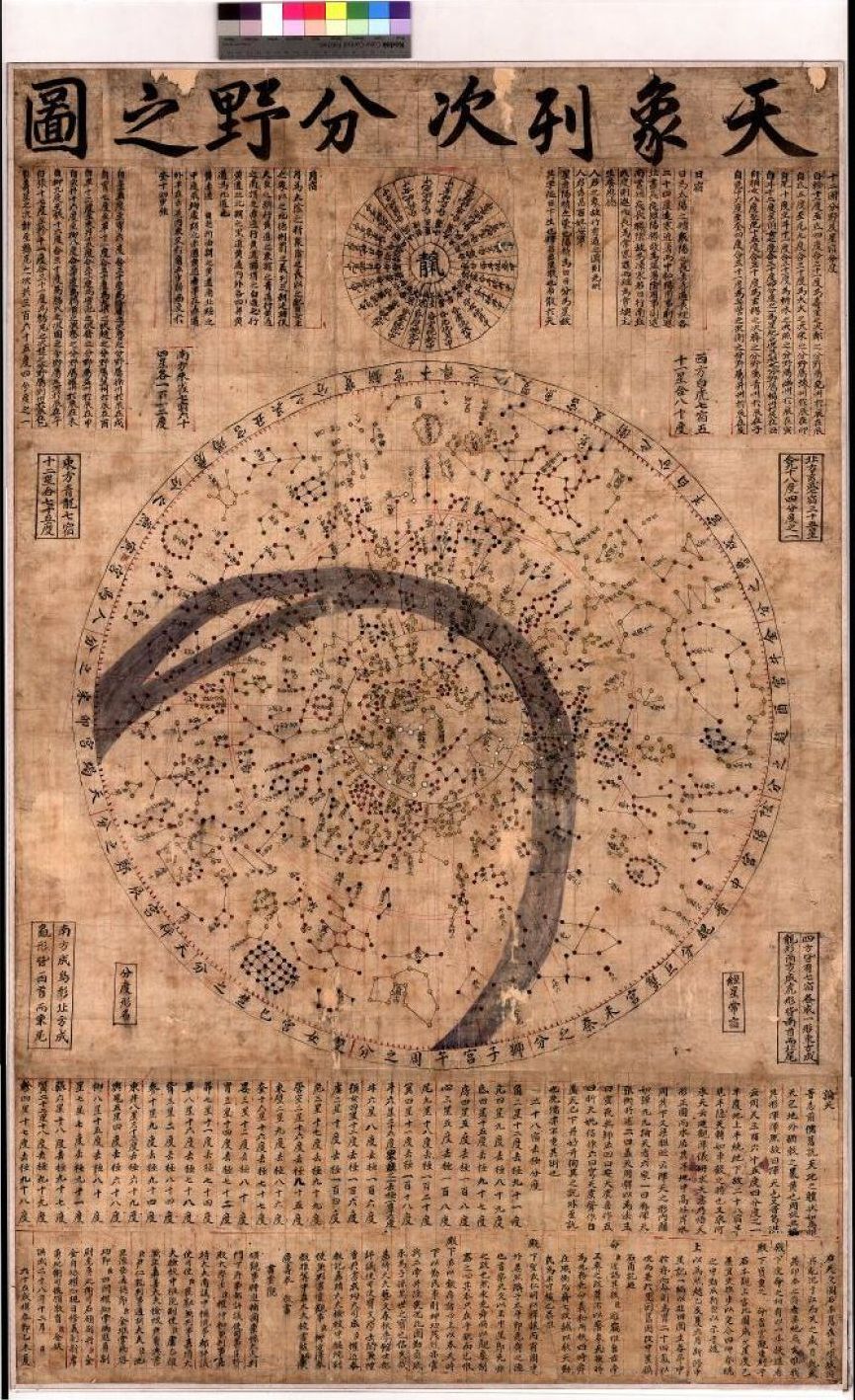
The Korean star chart, now located in the Astrophysical Institute, was presented to University Jena in 1958 at its 400-year anniversary by a northern Korean delegation. The original incised stone, probably from China, first stood in today’s Pyongyang, until it was lost during a conquest in 670. However, a rubbing survived and was given to the founder of the Yi dynasty in 1392. He was so impressed that he ordered a display on a marble stele. All this is explained in a text below the star chart; and several arguments, including astronomical, are consistent with this narrative. The new stele was erected in the new capital Seoul, where it is today located in a museum. In 1571, rubbings could still be made - but after several damages, a high quality replica was produced in 1687. The Jena copy was probably made from this marble stele. The title can be transcribed as Chonsang yolcha punya chido or Cheonsang yeolcha bunyajido, which means “natural order of celestial bodies and regions they reign”. It is made of parchment and leather, 138 cm times 87 cm in size (framed in wood under glass).
The planisphere shows more than 260 constellations, whose stars were more and more fixed during the Chinese Han dynasty. In our copy, the stars are displayed with a few different colors following the Chinese tradition. All constellations are labeled with name and number of stars (e.g. “Shen 10”, Shen is roughly the Babylonian-Greek Orion, seen in the lower right). In total, some 1500 stars are “ordered” in pattern, but their individual positions are not displayed with perfect precision.
The inclined, wavy, grey band of the Milky Way stands in some contrast to the otherwise fine “order”. A concentric circle in the middle defines the celestial equator, and another, inclined circle shows the ecliptic. While the inner circle delineates the ever visible stars (northern polar region), an outer circle marks the never visible region (around the southern pole). Thin lines show the borders of the so-called 28 Chinese lunar stations along the right ascension of the determinative stars of the corresponding 28 special constellations (without the polar regions); their equatorial coordinates are listed at the bottom below the chart.
In the field of Terra-Astronomy at the Astrophysical Institute of FSU Jena, pre-telescopic celestial observations (e.g. supernovae, novae, and comets) are used as epistemic key for current astrophysical problems; this work is undertaken in close collaboration with philosophy, history, philology (old languages), and the history of astronomy. The old star chart helps to better understand the rich historical transmission from the Far East.
Examples: https://doi.org/10.1093/mnras/stac1969 (star Betelgeuse was yellow 2000 years ago) or https://doi.org/10.1016/j.icarus.2020.114278 (orbit of comet Halley in the year 760); see https://www.astro.uni-jena.de/index.php/terra-astronomy.html
Dagmar L. Neuhäuser and Ralph Neuhäuser
References:
Ahn, S.-H., 2015, Astronomical characteristics of Cheonsang-yeolcha-bunyajido from the perspective of manufacturing methods, Journal of Astronomy and Space Sciences 32, p. 51-62, doi 10.5140/JASS.2015.32.1.51
Rufus, W.C., 1915, Korean's cherished astronomical chart, Popular Astronomy 23, p. 193
Stephensen, S.R., 1994. Chinese and Korean star maps and catalogs. In: Harley, J.B., Woodward, D. (Eds.), The History of Cartography, book 2: Cartography in the traditional East and Southeast Asian societies, vol. 2. University of Chicago Press, p. 511-578 (https://press.uchicago.edu/books/HOC/HOC_V2_B2/HOC_VOLUME2_Book2_chapter13.pdf)